The June 8 earthquake that struck Mindanao in the southern Philippines with a magnitude of 7.8 has left behind one of nature's most dramatic visible transformations: entire sections of the island's coastline have been thrust upward from the seafloor, fundamentally reshaping the landscape that coastal communities have known for generations. For Arsenio Butil Jr., a fisherman and pastor in Glan, Sarangani province, the moment the quake began was both terrifying and awe-inspiring. As the ground beneath his home shook violently, Butil fell to his knees in prayer, uncertain whether he would survive. When he looked up, he witnessed something few people ever see—the ocean itself seemed to be retreating before his eyes, revealing previously hidden coral formations and rocks that had been submerged for millennia.
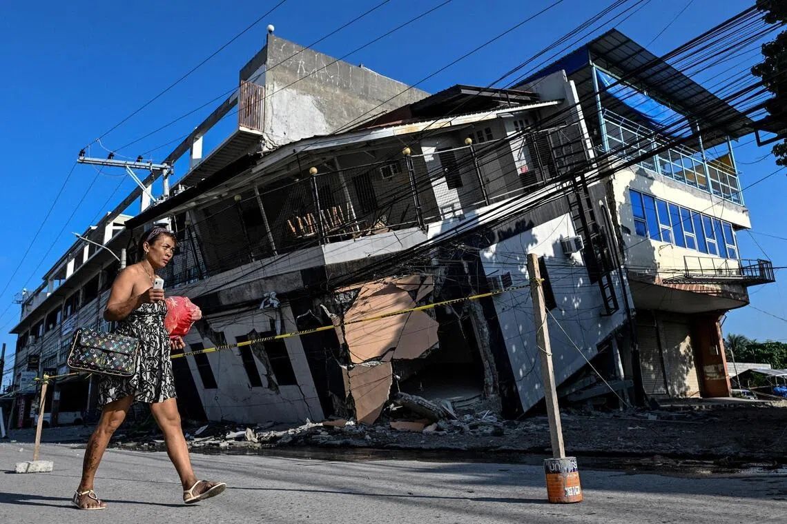
The catastrophic event claimed at least 76 lives across Mindanao and triggered numerous landslides that destroyed homes and infrastructure. Yet beneath the immediate humanitarian crisis lies a geological phenomenon that will permanently alter the region's geography and complicate recovery efforts for years to come. The tectonic forces responsible for the destruction operated along the Cotabato Trench, located just 50 kilometres offshore, one of the Pacific Ring of Fire's most active seismic zones. When the trench shifted, it didn't simply shake the island—it lifted substantial sections of the seafloor upward in a process geologists call coastal uplift, pushing the shoreline seaward by up to 200 metres in some locations across a stretch spanning nearly 100 kilometres.
Witnesses to this geological transformation describe scenes that seemed almost surreal. Fishing boats that had floated in deeper waters the day before now sat stranded on the wrong side of jagged coral walls that extended for kilometres in both directions. The dead coral, bleached white by exposure to air and sunlight, created an alien landscape where thriving fishing grounds once existed. Butil recounted how the water receded and returned multiple times during the earthquake, a phenomenon he witnessed with profound unease. The rapid changes in sea level, combined with the appearance of what had been the seafloor, created confusion and panic among residents who had spent their entire lives reading the ocean's normal patterns.
Seismologists at the Philippines' seismology centre confirm that the coastal uplift is permanent and represents a natural acceleration of geological processes that have shaped the archipelago over thousands of years. Nane Danlag, a scientist at the centre's General Santos City office, explained that the seabed rose approximately two metres, extending the shoreline permanently. She emphasised that while the changes appear dramatic to human observers operating on a timescale of decades, such tectonic movements have been occurring continuously throughout Earth's history, gradually building islands and reshaping coastlines. The affected population, however, struggles to accept this reassurance. For communities built on these shores, permanence brings not comfort but profound anxiety about what comes next.
The psychological impact on displaced residents reflects genuine concerns about future seismic activity. Approximately 100 people from a neighbouring village remain camped in the hills above their former homes, refusing to return despite the destruction being cleared away. Datu Atom Malimpnig, a Maguindanaon chieftain, articulated the fears haunting these communities: if the seabed could rise two metres in minutes, what might happen if it suddenly fell, creating a tsunami? The newly exposed coral wall, rather than providing reassurance that the ground is stable, serves as a constant reminder of the earth's terrifying power. Residents view their hillside encampment as sanctuary, and many seem reluctant to rebuild in locations that could be vulnerable to future geological upheaval.
The economic consequences extend far beyond fishing communities and subsistence livelihoods. The Isla Jardin del Mar resort, which depended on a pristine white sand beach as its primary commercial asset, now faces an uncertain future. Staff members observe that their once-attractive shoreline is now separated from the water by a wall of exposed, dead coral—a landscape that offers little appeal to tourists seeking tropical beach experiences. Edzel Baylon, a resort employee, expressed frustration about the sudden transformation of the destination's character. The shallow waters that now front what was once an inviting beach make swimming impossible, eliminating the core recreational experience that justified visitor expenditures. This represents just one of many tourism-dependent businesses facing unexpected economic disruption from geological forces entirely beyond human control.
The broader seismic context amplifies community concerns about stability and recovery timelines. The Cotabato Trench has been exceptionally active, with thousands of small tremors recorded in January—a phenomenon that some scientific assessments suggested might precede a major earthquake. The June 8 quake appears to have vindicated these warnings, though few residents would have paid attention to technical seismic reports. More concerning for those attempting to rebuild is the ongoing aftershock sequence: over 8,500 tremors have rattled the region since the initial event, a relentless reminder that the earth beneath these communities remains unstable and unpredictable. Structural engineers and residents alike view this continuation of seismic activity as a serious obstacle to reconstruction.
Butil Jr. and other residents contemplating rebuilding face daunting practical obstacles beyond psychological hesitation. The ground in Glan displays extensive cracking from the initial earthquake, damage that extends deep into the earth's crust. These visible fissures represent not merely cosmetic damage but evidence of structural weakness that makes the area genuinely dangerous for new construction. The prospect of another earthquake of similar magnitude striking while new buildings stand incomplete or recently finished creates a rational argument against rapid reconstruction. Insurance coverage for earthquake damage remains limited in the Philippines, leaving residents to bear financial losses themselves while confronting uncertain building safety. This combination of factors has prompted communities to adopt a cautious, wait-and-see approach rather than rushing to rebuild in a landscape they no longer fully understand or trust.
The transformation of the Mindanao coastline serves as a dramatic reminder of the geological forces that continue to shape Southeast Asia's geography. The region sits astride multiple major tectonic plate boundaries, making earthquakes and volcanic activity recurring features rather than rare anomalies. Other nations in the region, including Malaysia, Indonesia, and Thailand, face similar seismic and geological risks, though many lack the intensive monitoring and scientific expertise that the Philippines has developed. The Mindanao earthquake and its visible aftermath provide valuable lessons about preparation, community resilience, and the need for building standards that can withstand repeated seismic stress. The newly exposed coastline, while dramatic, pales in comparison to the human cost and disruption experienced by communities forced to fundamentally reimagine their relationships with the land and sea they depend upon for survival.


%22%2F%3E%3C%2Fpattern%3E%3C%2Fdefs%3E%3Crect%20width%3D%22100%25%22%20height%3D%22100%25%22%20fill%3D%22url(%23ph41c12g)%22%2F%3E%3Crect%20width%3D%22100%25%22%20height%3D%22100%25%22%20fill%3D%22url(%23ph41c12p)%22%2F%3E%3Ctext%20x%3D%2250%25%22%20y%3D%2250%25%22%20text-anchor%3D%22middle%22%20dominant-baseline%3D%22central%22%20fill%3D%22rgba(255%2C255%2C255%2C0.95)%22%20font-family%3D%22Georgia%2C%20'Times%20New%20Roman'%2C%20serif%22%20font-weight%3D%22700%22%20font-size%3D%22194%22%20letter-spacing%3D%22-0.02em%22%3EGerakan%3C%2Ftext%3E%3C%2Fsvg%3E)