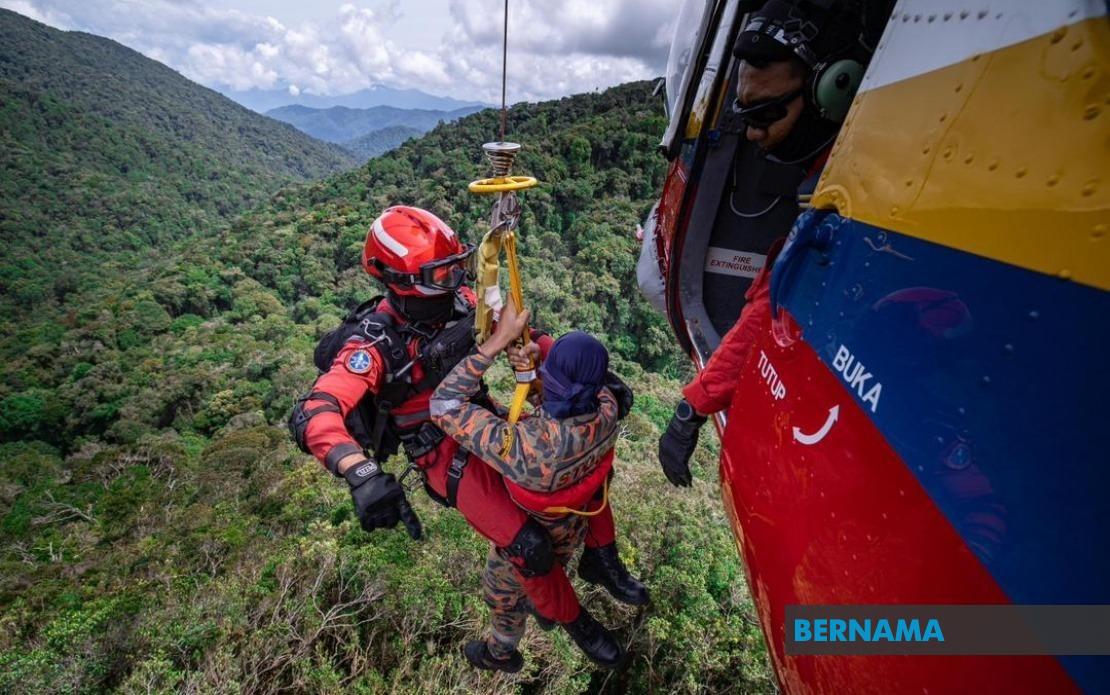
Malaysia's growing enthusiasm for hiking and forest recreation has come with a sobering toll. Between 2021 and 2025, the country recorded 1,059 accidents across hiking activities nationwide, resulting in 63 fatalities and 87 injuries, Deputy Minister of Natural Resources and Environmental Sustainability Syed Ibrahim Syed Noh disclosed to Parliament this week. The figures, compiled by the Fire and Rescue Department of Malaysia, underscore the urgent need to bolster safety infrastructure as more Malaysians venture into the nation's diverse mountain ranges and forest reserves.
The upward trajectory of hiking accidents reflects a broader regional trend. As Malaysia's urban middle class expands and wellness consciousness grows, outdoor activities have transitioned from niche pursuits to mainstream pastimes. Social media amplification of scenic hiking locations, coupled with improved accessibility and reduced costs, has democratised mountain recreation. Yet this democratisation has not been matched by proportional investment in safety systems, creating a gap between demand and protective capacity that the government now seeks to address.
To manage these risks systematically, the Peninsular Malaysia Forestry Department has developed the Mountain Risk Assessment and Management Guideline, or MoGRAM, in collaboration with the United Nations Development Programme. This technical framework serves as a standardised reference for evaluating terrain hazards, determining safe visitor numbers per trail, and implementing mitigation strategies. Rather than relying on ad-hoc assessments, MoGRAM provides forestry officials with evidence-based methodologies to identify vulnerabilities—from unstable slopes and water crossings to exposure zones—and calibrate intervention levels accordingly.
A cornerstone of the government's safety initiative involves mandating certified Forestry Mountain Guides in 189 high-risk hiking areas across Peninsular Malaysia. These guides, known locally as MGPs, undergo rigorous training in emergency response protocols, terrain navigation, and hiker management. To date, 2,322 individuals from local and indigenous communities have earned MGP certification through dedicated skills development programmes. This approach serves dual purposes: it creates employment pathways for rural communities while establishing a professional cadre responsible for on-ground safety and compliance monitoring. The emphasis on hiring local guides also preserves cultural knowledge of mountain ecosystems and traditional navigation practices.
Beyond personnel, the government is deploying technology to enhance trail management and emergency response. The Peninsular Malaysia Forestry Department, partnering with the Malaysian Space Agency, is developing an integrated hiking trail management system utilising geospatial technology, Geographic Information Systems, and remote sensing capabilities. This platform will map hiking routes with unprecedented precision, track trail conditions in real time, and identify hazardous sections requiring maintenance or access restrictions. During emergencies, the system's spatial data will enable search and rescue teams to pinpoint lost hikers more rapidly and coordinate response efforts across multiple agencies.
Currently, hiking activity registration in Permanent Reserved Forests remains fragmented. State forestry departments manage permits and logs independently, reflecting Malaysia's federal structure where land and forestry fall under state jurisdiction. Some states employ manual registration systems, while others utilise basic online platforms, creating inconsistencies in data quality and accessibility. The government recognises this fragmentation as a critical vulnerability, particularly when hikers venture across state boundaries or disappear in remote areas. Syed Ibrahim indicated that a national digital registration system could standardise data collection, enabling authorities to track hiker movements systematically and accelerate emergency tracing procedures when incidents occur.
The proposed national digital registry would represent a significant departure from current practices. Rather than decentralised, paper-based logs, a unified platform could record entry and exit times, trail routes, group composition, and contact information in real time. Such transparency would allow forestry officials to identify overdue hikers within hours rather than days, substantially improving rescue outcomes. The system could also implement dynamic capacity limits, automatically preventing trail access once safe visitor thresholds are reached during peak periods. For Southeast Asian neighbours grappling with similar challenges—from overcrowded trails in Thailand to unregulated hiking in Philippines national parks—Malaysia's pilot approach could offer transferable lessons.
The investment in guide training reflects growing recognition that technical infrastructure alone cannot ensure safety. Mountain guides operate as educators, communicators, and decision-makers in fluid, unpredictable environments. Beyond first aid and rescue techniques, MGP curricula now emphasise weather interpretation, route adaptation, and psychological support during emergencies. Regular certification renewals ensure guides remain current with evolving best practices and incident analysis. This human-centred approach acknowledges that hiking safety ultimately depends on thousands of daily judgement calls made by individuals on the ground, not merely on digital systems or regulatory frameworks.
For Malaysian hikers, these measures signal a maturing safety ecosystem. Novice trekkers benefit from certified guides who can advise on fitness requirements, appropriate gear, and realistic timelines. Experienced hikers gain access to standardised trail information and real-time conditions data. Local communities, particularly indigenous groups with ancestral knowledge of forest terrain, find economic opportunities and recognition of their expertise. The government, meanwhile, accumulates data that informs long-term policy—identifying accident hotspots, understanding causation patterns, and refining prevention strategies iteratively.
However, systemic implementation remains uneven. While 189 high-risk areas now require guides, thousands of secondary trails lack formal oversight. The digital registration system exists primarily as a proposal, with no announced timeline for full deployment. Budget constraints may limit MGP hiring in less-visited reserves. Enforcement of compliance presents ongoing challenges, particularly where hikers disregard trail closures or undertake unregistered climbs. The government's multi-layered approach—combining regulation, professional capacity, technology, and community engagement—indicates strategic intent, yet sustained political will and adequate resourcing remain essential.
The broader context matters for regional observers. Malaysia's hiking accident figures, while alarming in absolute terms, reflect the country's advanced documentation systems and relatively high participation rates. Many Southeast Asian nations likely experience comparable or higher incident numbers but lack systematic recording mechanisms. The government's decision to develop MoGRAM, invest in guide certification, and pursue digital registration suggests recognition that outdoor recreation is now integral to Malaysia's tourism economy and social fabric. Rather than restricting access—an approach that would invite political resistance—authorities are choosing to professionalise and systematise risk management. This pragmatic middle path, if executed effectively, could become a model for balancing recreation, safety, and economic development across the region.