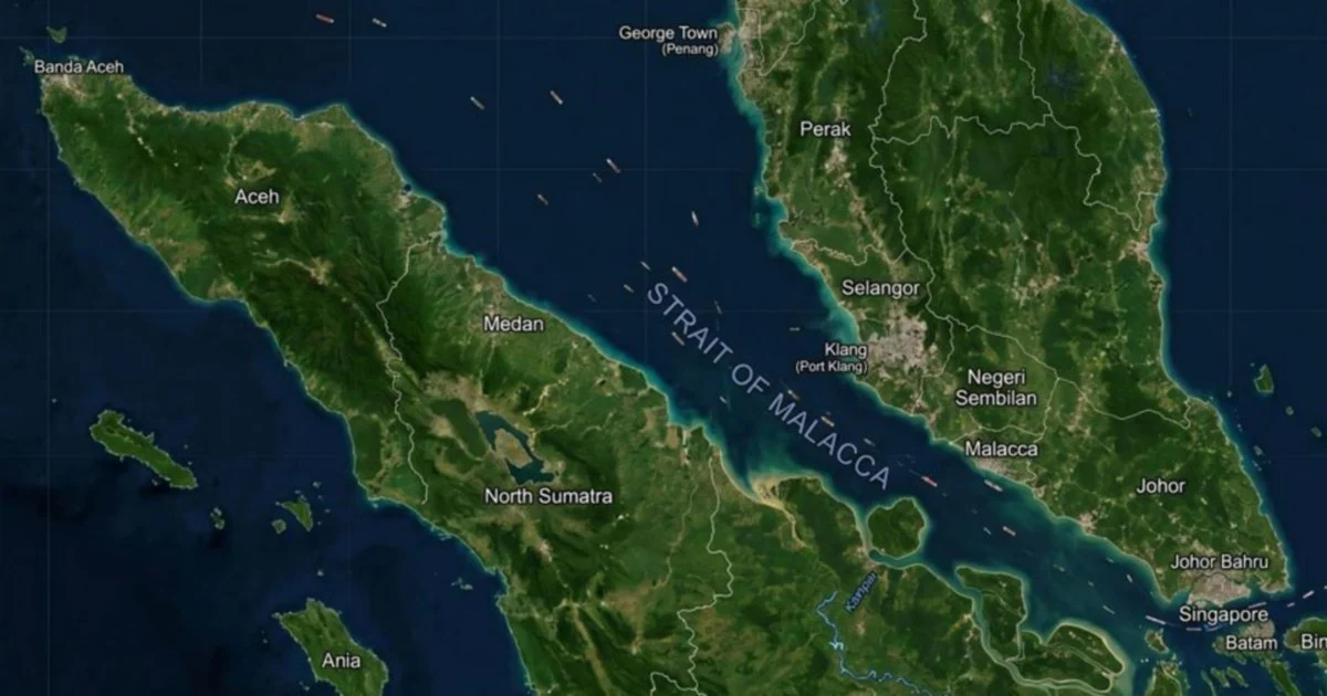
Malaysia's capacity in hydrographic surveying and charting has emerged as a cornerstone of maritime security in one of the world's most strategically important waterways. Officials at the National Hydrography Centre, speaking from Port Klang, underscored that the nation's hydrographic capabilities are indispensable in preserving both the safety and freedom of passage through the Strait of Malacca, a maritime corridor that carries roughly one-quarter of global seaborne trade and links the Indian Ocean to the Pacific.
The Strait of Malacca remains one of the most heavily trafficked shipping lanes globally, with approximately 94,000 vessels transiting its waters annually according to international maritime data. The waterway serves as a vital conduit connecting the Middle East oil supplies to East Asian markets, making it critical to regional and global economic stability. Despite its commercial importance, the strait presents considerable navigational challenges due to variable water depths, shifting seabeds, monsoon patterns, and narrow passages that demand precise nautical charts and real-time hydrographic intelligence.
Hydrographic surveying involves the systematic measurement and charting of underwater features, sea depths, currents, tides, and hazards that could threaten vessel navigation. Accurate hydrographic data forms the foundation of nautical charts and navigational aids that guide commercial shipping, naval operations, and maritime rescue efforts. Malaysia's accumulated expertise in this specialized field positions the nation as a custodian of regional maritime knowledge, enabling the provision of reliable information to international shipping communities and neighbouring states sharing responsibility for the strait's management.
The National Hydrography Centre functions as Malaysia's primary institution for collecting, analysing, and disseminating hydrographic information relevant to Malaysian waters and shared maritime zones. By maintaining contemporary survey data and updating navigational charts, the centre contributes to hazard mitigation and route optimization for vessels. This technical capability also supports Malaysia's role in international maritime organizations and bilateral agreements governing passage through the strait, demonstrating how sophisticated hydrographic services translate into tangible diplomatic influence and maritime governance.
Beyond commercial shipping, hydrographic data underpins several critical maritime functions. Naval and coast guard operations depend on detailed underwater knowledge for security patrols, search and rescue missions, and anti-piracy efforts. Environmental management, particularly monitoring of marine ecosystems and responses to pollution incidents, requires baseline hydrographic information. Furthermore, the data informs infrastructure planning for ports and coastal development, sectors vital to Malaysia's economic development and regional shipping hub ambitions.
The strategic significance of Malaysia's hydrographic role extends beyond technical expertise to geopolitical considerations. As a coastal nation with direct control over portions of the Strait of Malacca and established maritime boundaries, Malaysia occupies a position where hydrographic knowledge becomes leverage in regional maritime governance. Countries transiting the strait increasingly depend on Malaysian hydrographic data to ensure passage safety, creating reliance that strengthens Malaysia's voice in discussions about strait management, security protocols, and dispute resolution mechanisms.
Regional maritime security faces evolving challenges ranging from piracy and smuggling to environmental concerns and navigational accidents. Hydrographic capabilities contribute to addressing these threats by enabling early warning systems for hazardous conditions, supporting coordinated maritime law enforcement, and facilitating incident investigation. In this context, Malaysia's hydrographic infrastructure serves not merely as a technical service but as a public good supporting the broader maritime security architecture of Southeast Asia and the Indian Ocean region.
International recognition of Malaysia's hydrographic work manifests through cooperation with global maritime authorities, including the International Maritime Organization and the International Hydrographic Organization. Such partnerships validate Malaysia's technical standards and position the nation as a reliable partner in international maritime governance frameworks. These connections also enable knowledge exchange, capacity-building initiatives, and collaborative surveying projects that strengthen regional maritime resilience.
The economic implications of maintaining hydrographic excellence warrant consideration as Malaysian ports, including Port Klang and others, compete for regional shipping dominance. Accurate, up-to-date hydrographic information attracts shipping operators seeking predictable, safe transit routes. Port operators and logistics providers in Malaysia can market their services with confidence backed by superior navigational intelligence. This technical advantage translates into competitive positioning within Southeast Asia's dynamic maritime sector, where efficiency and safety standards determine port selection decisions by international carriers.
Looking forward, Malaysia's hydrographic capabilities require sustained investment and technological advancement. Climate change-induced sea level variations, increased maritime traffic, and emerging maritime security threats demand continuous monitoring and data refinement. Upgrading surveying equipment, expanding coverage of critical waterways, and integrating advanced technologies such as autonomous underwater vehicles and satellite-based systems represent priorities for maintaining hydrographic relevance and operational effectiveness.
The National Hydrography Centre's emphasis on Malaysia's hydrographic role reflects broader recognition that maritime security fundamentally depends on technical knowledge and institutional capacity. By maintaining excellence in hydrographic services, Malaysia reinforces its position as a responsible maritime stakeholder invested in keeping the Strait of Malacca safe, navigable, and economically productive for all users. This capacity, though often operating behind the scenes, constitutes a cornerstone of regional maritime stability that benefits Malaysia and the international shipping community.
%22%2F%3E%3C%2Fpattern%3E%3C%2Fdefs%3E%3Crect%20width%3D%22100%25%22%20height%3D%22100%25%22%20fill%3D%22url(%23phqvhzg)%22%2F%3E%3Crect%20width%3D%22100%25%22%20height%3D%22100%25%22%20fill%3D%22url(%23phqvhzp)%22%2F%3E%3Ctext%20x%3D%2250%25%22%20y%3D%2250%25%22%20text-anchor%3D%22middle%22%20dominant-baseline%3D%22central%22%20fill%3D%22rgba(255%2C255%2C255%2C0.95)%22%20font-family%3D%22Georgia%2C%20'Times%20New%20Roman'%2C%20serif%22%20font-weight%3D%22700%22%20font-size%3D%22194%22%20letter-spacing%3D%22-0.02em%22%3EKuching%3C%2Ftext%3E%3C%2Fsvg%3E)