Japan faces a significant weather emergency as the country's meteorological authority issued warnings Friday for two separate typhoons converging on the archipelago, with both systems expected to make landfall during the following 48 hours. The dual threat—Typhoon Higos approaching from the Pacific and Typhoon Mekkhala already affecting southwestern regions—has prompted authorities to implement extensive evacuation protocols affecting millions of residents, whilst meteorological specialists anticipate intensified precipitation patterns across vulnerable population centres through the weekend.
The Japan Meteorological Agency has expressed particular concern about the timing and trajectory of both systems. Typhoon Higos was forecast to approach from the southern Pacific coast and move northward over the country, whilst Typhoon Mekkhala had already reached the Amami region in Kagoshima Prefecture by Friday morning and demonstrated potential to drift toward the more densely populated Kanto region to the northeast. The convergence of these two weather systems creates a compound meteorological hazard, with authorities warning that overlapping rainfall zones could generate severe cumulative precipitation totals across critical areas.
By Friday morning, the Fire and Disaster Management Agency had documented evacuation orders affecting more than 2 million people distributed across 13 prefectures spanning the Kinki and Kyushu regions. This represents a substantial population displacement driven by expectations of hazardous conditions including landslides, flooding, and possible infrastructure damage. In Seika, Kyoto Prefecture, local authorities activated the highest level 5 emergency safety alert for specific zones after an early morning landslide event demonstrated the immediate geological risks posed by sustained heavy precipitation.
Rainfall measurements recorded across affected regions underscore the severity of accumulated moisture already delivered by preceding weather systems. The Japan Meteorological Agency documented 600 millimetres of rain that accumulated in Goto, Nagasaki Prefecture, over the four-day period from Tuesday through Friday morning. Additional data showed that Aso in Kumamoto Prefecture and Ureshino in Saga Prefecture each received over 500 millimetres during the same timeframe, saturating ground substrates and elevating landslide probability as further precipitation arrives with the approaching typhoons.
Projections indicate that rainfall intensity will escalate significantly across central and eastern Japan as Typhoon Higos progresses northward along the southern coast. The Tokai region is expected to receive up to 300 millimetres of additional rainfall by noon Saturday, whilst the Kanto-Koshin zone anticipates precipitation accumulation reaching 150 millimetres during the same period. These forecasted amounts would compound existing soil moisture conditions and substantially increase flood and debris-flow risks across river systems and mountainous terrain.
For Malaysian and Southeast Asian observers, Japan's typhoon preparedness system offers instructive lessons in integrated disaster management. The country's multi-tiered alert system, which escalates from advisory to emergency safety warnings based on quantified hazard thresholds, provides a model framework for regions across Southeast Asia that face comparable tropical cyclone threats. The willingness to issue mass evacuation orders affecting millions of residents demonstrates the Japanese approach of prioritizing precautionary relocation over reactive rescue operations, a principle that contrasts with resource constraints often limiting such decisions in developing economies.
The meteorological agency's assessment that both typhoons would weaken into extratropical cyclones after making landfall provides moderate reassurance regarding the duration of severe conditions, though the agency explicitly cautioned that even weakened systems retain capacity to generate dangerous secondary hazards. Landslide potential and urban flooding remain elevated for extended periods following typhoon passage, as terrain destabilization and drainage system saturation create cascading risks beyond the primary wind and precipitation phases.
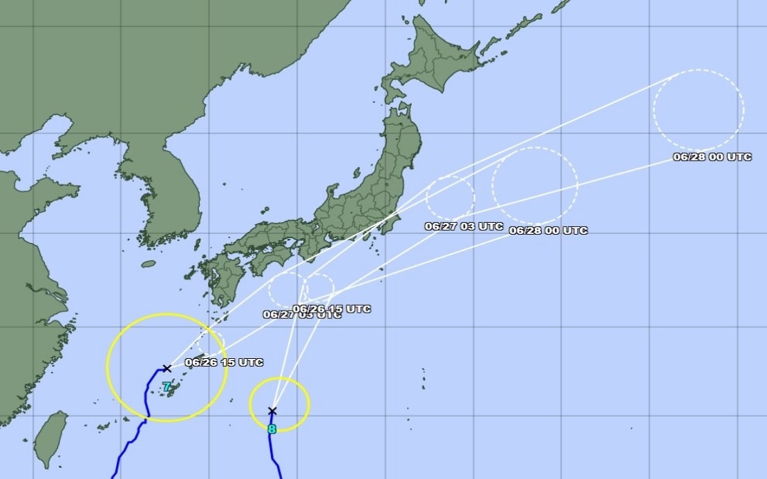
As Typhoon Mekkhala tracked northeast at 15 kilometres per hour off Kume Island in Okinawa Prefecture by Friday mid-morning, the forecasting sequence entered a critical window where minor trajectory adjustments could substantially alter regional impact patterns. The Japan Meteorological Agency maintained heightened alert status for Okinawa Prefecture and eastern Japan, recognising that storm positioning uncertainty at this temporal distance necessitates sustained public vigilance rather than region-specific reassurance.
The dual-typhoon scenario highlights the vulnerability created when multiple weather systems approach within short temporal intervals, preventing full resource mobilization and recovery between successive impact events. Emergency management agencies, medical facilities, and utility providers must sustain heightened operational readiness across overlapping hazard windows, creating logistical constraints that can compromise response capacity for any single system. Regional authorities across Southeast Asia, particularly those managing coastal and mountainous zones subject to monsoon and typhoon impacts, confront comparable simultaneous-event scenarios with comparatively smaller institutional reserves.
Japan's response mobilization demonstrates the value of pre-established evacuation centres, early warning systems calibrated to regional topography, and public familiarity with emergency protocols cultivated through sustained educational campaigns. The rapid deployment of evacuation orders affecting millions reflects both technological sophistication in hazard forecasting and institutional capacity to coordinate large-scale population movements. For neighbouring Southeast Asian nations, the systematic Japanese approach to anticipatory rather than reactive disaster response offers a potentially valuable reference model for policy adaptation, particularly as climate-related intensification of tropical storm frequency and severity becomes an increasingly apparent risk factor across the regional environment.